This first map is an edition from about 1888 and shows the Aberdare
Park area before the school was built in 1896. The piece of land opposite the entrance
to the park was an empty field (called Comin Bach according to a local history) but
the three chapels behind the school are evident at this time.
Boys who attended the school came from a wide area (or length?) of the Cynon Valley
and the next three maps show developments in the valley since the second World War.
There are marked differences in the built-up area in the 1947 and the 1956 maps. At
the top end of the valley, the Bryn residential estate in Rhigos, and the Trading
Estate near Hirwaun, were built. Further down the valley the residential estates in
Penywaun and Cwmbach also appear. By 2003, of course, the notable changes are the
loss of the collieries and the railway lines, and the new roads through the valley.
There was another Grammar School in Mountain Ash which was co-educational, and
it’s not clear to me why some pupils were selected for this school and others
for the Aberdare schools. For example my older sister was sent from Rhigos Primary
School to Mountain Ash Grammar School while I was sent to the Aberdare Boys Grammar
School. Secondary school children from Rhigos were collected by a special school bus
(Western Welsh) at about 8:25 for the journey to school. As we travelled such a long
way (about 5 miles) we were also provided with free season tickets for the journey.
I think that boys who lived within 2 miles (?) of the school were expected to
walk. We would still use these season tickets if we travelled home late after detention,
and were often told off by the conductor for not using the school bus provided, adding
insult to injury!
The next map shows the area of the school about 1973 after the school itself had
moved to the Cwmdare Hill site, though the building was still standing and in use
as offices. This is a large scale map which show lots of interesting detail in the
streets around, and in the park.
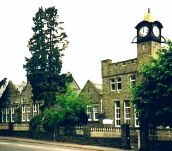
Finally here’s a link to the Google Maps page showing a high resolution satellite
image of the area around the school. The images were made around 2003 as the picture
shows that the school has been demolished and only the School House and the clock
tower are left.
|