
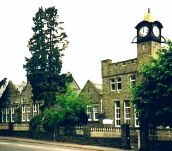
Aberdare Boys’ Grammar School
Memories & Memorabilia
Field Trips 1948
An item from the papers of the late Tom Evans. Head of Geography, 1948–1979
from Gwyn Evans
This account seems to be a report on field trips undertaken by pupils
in 1948.
Tom Evans joined the school in September 1948, so presumably his predecessor,
D.T.H. Price, was the organiser.


A transcript of the above sheets
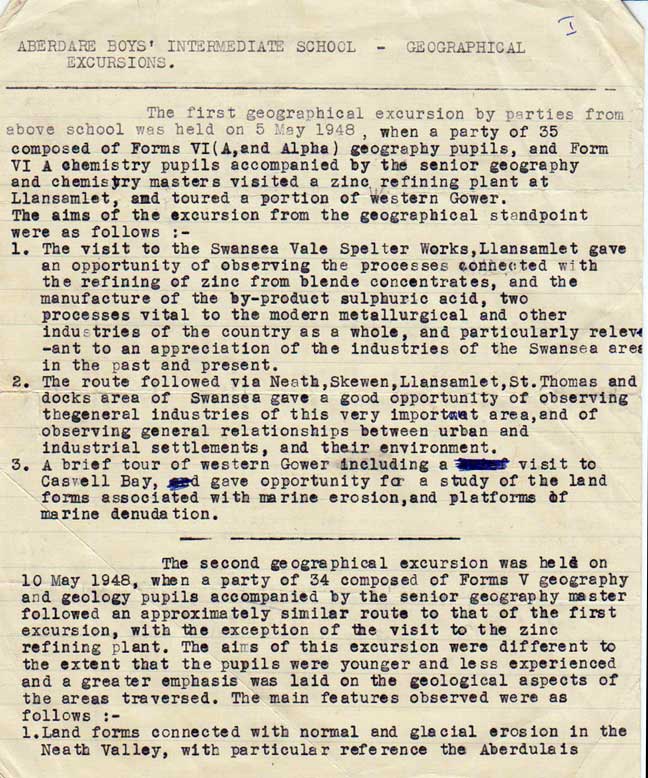
ABERDARE BOYS’ INTERMEDIATE SCHOOL — GEOGRAPHICAL EXCURSIONS
The first geographical excursion by parties from above school was held on 5 May 1948, when a party of 35 composed of Forms VI (A, and Alpha) geography pupils, and Form VI A chemistry pupils accompanied by the senior geography and chemistry masters visited a zinc refining plant at Llansamlet, and toured a portion of western Gower.
The aims of the excursion from the geographical standpoint were as follows :—
- The visit to the Swansea Vale Spelter Works, Llansamlet gave an opportunity of observing the processes connected with the refining of zinc from blende concentrates, and the manufacture of the by-product sulphuric acid, two processes vital to the modern metallurgical and other industries of the country as a whole, and particularly relevant to an appreciation of the industries of the Swansea area in the past and present.
- The route followed via Neath, Skewen, Llansamlet, St. Thomas and docks area of Swansea gave a good opportunity of observing the general industries of this very important area, and of observing general relationships between urban and industrial settlements, and their environment.
- A brief tour of western Gower including a visit to Caswell Bay, gave opportunity for a study of the land forms associated with marine erosion, and platforms of marine denudation.
The second geographical excursion was held on 10 May 1948, when a party of 34 composed of Forms V geography and geology pupils accompanied by the senior geography master followed an approximately similar route to that of the first excursion, with the exception of the visit to the zinc refining plant. The aims of this excursion were different to the extent that the pupils were younger and less experienced and a greater emphasis was laid on the geological aspects of the areas traversed. The main features observed were as follows :—
- Land forms connected with normal and glacial erosion in the Neath Valley, with particular reference the Aberdulais
end-morriane and other evidence of glacial and fluvic-glecial deposits.
- Land forms associated with marine deposition end erosion as illustrated by the sand dune region at Jersey Marine, and Swansea Bay, together with the Gower coast between Oystermouth and Pennard.
- General features of human and economic geography of the Neath-Swansea-West Gower area, as indicated by characteristic industries, agriculture etc.
The third geographical excursion was held on 21 May 1948 when a party of 34 composed of Forms V geography and geology pupils accompanied by the senior geography master made a tour covering the following route :—
Out :— Aberdare, Pontypridd, Cardiff, Penarth.
In :— Penarth, Cardiff, Caerphilly, Nelson, Aberdare,
The tour included a visit of approx 1½ hrs. duration to the National Museum of Wales where special attention was paid to the collections in the Geology and Folk Craft sections.
During the tour the main features studied were :—
- Settlement in the Cynon and Taff valleys, and the site of the new coke oven plant at Nant-garw.
- Site of Cardiff and study of locational factors from such vantage points as Leckwith and the Caerphilly road.
- Marine erosion and the outcrops of Trias and Lias rocks in the Penarth area.
The route followed provided an interesting contrast, covering as it did the south crop of the coalfield and marginal areas of coastal regions in younger rocks as compared with the home area on the north crop of the coalfield.
The fourth geographical excursion was held on 27 May 1948 when a party of 33, composed of Forms VIA & α Geography & some pupils from Form V, accompanied by the senior geography master made a tour covering the following route :—
Out :— Aberdare, Rhigos, Treherbert, Blaengwynfi, Port Talbot, Margam.
In :— Margam, Porthcawl, Bridgend, Llantrisant, Pontypridd, Aberdare.
The main purpose of the excursion was a conducted visit of the Margam carbide plant, the only example of the industry at
present in the country. A preliminary lecture outlining the sources of raw materials (Limestone and coke) and the main features of the process itself was followed by a complete tour of the plant itself.
Among other subjects of interest observed on the tour were :—
- General features of the geology of the Pennant scarp and upper Rhondda Valley, the plateau of ‘Blaenau Morganwg', and the Afan Valley.
- General features of settlement and industry in the upper Rhondda and Afan Valleys.
- The location and function of the port of Port Talbot together with factors contributing to the choice of the Margam-Port Talbot site for the new steel works and ‘strip mill’ to be located there.
- Coastal sand dune country in the Kenfig area, and general features of coastal topography in the Porthcawl area.
- General characters of the ‘Vale’ and its margins as illustrated in the Bridgend-Pencoed-Llantrisant area.
During the 1947–48 session numerous shorter excursions have been conducted in the school area itself with the aim of
- Studying local geology as demanded by the syllabus of the C.W.B. at the Senior stage,
- Studying the local geographical setting as demanded by the C.W.B. syllabus at the Senior and Higher stages.
Among the areas specially studied have been :—
- The Ystradfellte and Porth-yr-ogof area.
- The lower Mellte valley (Clyngwyn Falls).
- The Craig-y-ddinas and Pont-nedd-fechan area.
- The Perddyn Valley (Sgwd-Einion-Gam and Sgwd-Gwladys)
- The Bwllfa and ‘Graig’ area.
- The Dyllas and Llwydcoed area.
- The Cynon valley between Aberdare and Hirwaun.